Tough and easy-to-handle operation terminal, perfect for any application under harsh conditions
Possible applications
collection of measuring values
programming and readout of data loggers
visualisation of measuring data in hydrograph and list form
measurement of discharge with hydrological current meter, Aqua Profiler and Stream Pro
route planning and finding of measuring sites with offroad and street navigation


logger programming entering ecanting values discharge measurements
with current meter


Streampro handling finding measuring sites
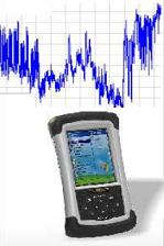
The Hydrological Digital Assistant SEBA HDA
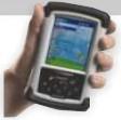
The SEBA-HDA is the multifunctional handheld for water management. It is shock-resistant, easy-tohandle, lightweight and waterproof. Therefore it is a perfect assistant to cope with numerous tasks on- site. Equipped with comfortable SEBA software tools, the HDA allows programming and setting of all data loggers within the SEBA product line (e.g. SEBA data loggers MDS-Dipper 2, MDS-Floater, LogCom etc.). The data visualisation and justification software MGMDSce ensures a clear illustration of time series in the form of hydrographs and lists. The software “Level Observer” allows a comfortable collection of measuring values (e.g. contact meter measurements). In addition the HDA replaces traditional counting devices for discharge measurement. The Software Qce permits both the processing of propulsion impulse (e.g. SEBA current meter F1) and the direct analysis of discharge measurements on-site. The HDA also serves as an operation terminal for the mobile ADCP measurement system SEBA Aqua Profiler and Stream Pro by RDI. Optionally,the HDA can be equipped with a GPS system. With the help of a user-friendly route planning software the HDA targets you to your measuring site even in an impassable territory.
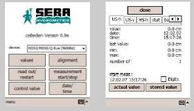
Bedien ce - comfortable handling and readout of SEBA MDS data logger
User-friendly application software for all SEBA loggers within the MDS product line. Possible entry of encanting values. Convenient programme linkage with MGMDSce to graphically visualize current data. The collected measuring values are transferred to the PC via USB cable.
The SEBA database software “DEMASdb“ or other commercial programmes (e.g. WISKI, MSExcel etc.) provide a comfortable processing and archiving of the measured data.
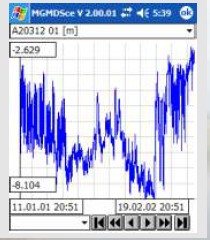
MGMDS ce - visualisation of time series in form of hydrographs and lists
MGMDS ce displays time series as hydrographs and lists in a comfortable way. The user has the possibility to check the quality of the collected values locally at a glance. A scroll function allows to enlarge and view different time periods if required.
MGMDSce has a conversion function, which converts your measured data into ASCII data.
A list view of the measured data and information about the measurement round off the operational range of MGMDSce.

Level Observer - the digital notebook for value entering
Notepad and ballpen are a thing of the past. With the use of the Level Observer it is possible to enter the tapping value using the barcode scanner or the extra large user interface.
The software -which is included in delivery -can generate barcodes individually for your measuring sites. The data are exported in ASCII format so that they can be easily processed with DEMASdb or other programmes (e.g. MSExcel).

Q ce Discharge measurement simplified
Turn your HDA into a signal counter. In combination SEBAQce the HDA stores and visualises propulsion measurements. The data exchange is effected on your PC via SoftwareQ 3.0. All measuring sites, devices and teams previously saved in SoftwareQ are on the HDA ready to be retrieved.

Every measurement is logged by a data base. You can continue aborted measurements at a later date or load new measurements. A list displays all available/ selectable measuring points.

After a measurement the data can be transferred to the computer in a SoftwareQ-format and then imported in
Software Q.

GPS module - Finding measuring sites, route planning and optimisation
Optionally you can upgrade the HDA with a GPS module. Your HDA leads you safely to your measuring sites without any detours, regardless if it is street or offroad navigation . In addition you can optimise the route in a comfortable way saving time and money.
Features of optional software packages:
- Pure Street Navigation "TomTom Navigator"
- Offroad Navigation "PathAway" Software
- Personal Points of Interest / Waypoints e.g. capture your measuring
sites and record their description
- Route localisation (e.g. of the measuring sites to be approached)
- Record and Follow your Tracks. Record your tracks as you travel.
Then, follow the recorded track to find your way home
- Display previously captured measuring sites
- Individual maps can be deployed
- TTQV - Import your own maps e.g. from mapping websites,
CD-ROM, scanned or digitally photograped on your Desktop-PC
then transfer the data onto your SEBA-HDA.

Technical data
Standard features:
-Windows Mobile 5.0 (Premium edition)
-200 MHz or 400 MHz
-64 MB high-speed SDRAM
- 128 MB or 256 MB nonvolatile Flash storage
- color TFT display - readable under sunlight conditions
-touchscreen
- rugged waterproof design
- integrated speaker and microphone
- 15 hours of continuous room-temperature operation with default settings
General data:
- size: 16,5 x 9,5 x 4,5 cm (6,5 x 3,75 x 1,75”)
-weight: 490 g (17 ounces)
- operating temperature: -30°C to 60°C
-protection class: IP 67
Electronics:
- processor: Intel PXA 255 XScale CPU, 200 MHz ( Recon 200X), 400 MHz ( Recon 400X)
- display: 240x320 pixel (1/4 VGA) color TFT with LED-light
-batteries: 3800 mAh NiMH rechargeable pack
Accessories:
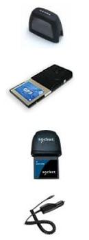
-GPS module with street and/or offroad navigation software
-Barcode laser scanner incl. software “Level Observer”
-Bluetooth module for mobile ADCP type .StreamPro“
-Impuls converter incl. “Software Qce” for propulsion measurement
-carrying bag with belt clip and shoulder strap
-1,2 or 4 GB SD card with extended temperature zone
-12V car charging adaptor
The right is reserved to change or amend the foregoing technical specification without prior notice.
Producing Area:Germany